No edit summary |
|||
| (12 intermediate revisions by 8 users not shown) | |||
| Line 1: | Line 1: | ||
[[File:Algonquin Dukes Expressway.jpg|thumb|250px]] |
[[File:Algonquin Dukes Expressway.jpg|thumb|250px]] |
||
| − | The '''Algonquin - Dukes Expressway''' is a 1.9 mile freeway that connects [[Algonquin]] to [[Dukes]] in [[Liberty City |
+ | The '''Algonquin - Dukes Expressway''' is a 1.9 mile freeway that connects [[Algonquin]] to [[Dukes]] in [[Liberty City (HD Universe)|Liberty City]] in [[Grand Theft Auto IV]] and [[Grand Theft Auto: Chinatown Wars]], with three intersections in Liberty City. It connects [[Algonquin Bridge]] with the [[Francis International Airport, Dukes|Francis International Airport]] via northern [[Broker]] and southern [[Dukes]]. |
| − | Of all the Expressways in Liberty City, the Algonquin-Dukes Expressway possesses the most freeway-like features, with sophisticated exit/entrance infrastructure and isolation from road networks. |
+ | Of all the Expressways in Liberty City, the Algonquin-Dukes Expressway possesses the most freeway-like features, with sophisticated exit/entrance infrastructure and isolation from road networks. It is also the only expressway with hard shoulders. |
Other Expressways do possess these features, but not for their full lengths. |
Other Expressways do possess these features, but not for their full lengths. |
||
| − | It is most likely based |
+ | It is most likely based on the [[wp:Interstate 495 (New York)|Midtown-Queens Expressway]] being part of the [[wp:Long Island Expressway|Long Island Expressway]] in [[wp:New York City|New York City]]. The fact that [[Algonquin Bridge]] carries the expressway is based on the planned-but-unbuilt [[wp:Lower Manhattan Expressway|Lower Manhattan Expressway]]. |
==Length== |
==Length== |
||
The length of the Algonquin-Dukes Expressway is of 1.9 mile from the Lancet entrance/exit to the end of the loop the highway performs aound the parking lot of Francis International Airport. |
The length of the Algonquin-Dukes Expressway is of 1.9 mile from the Lancet entrance/exit to the end of the loop the highway performs aound the parking lot of Francis International Airport. |
||
== Exits and Entrances == |
== Exits and Entrances == |
||
| − | The freeway travels West - East from the [[Lancet]], [[Midtown Algonquin]] to [[Francis International Airport, Dukes]] [[Albany Avenue]] intersection. There are four exits/entrances between these two |
+ | The freeway travels West - East from the [[Lancet]], [[Midtown Algonquin]] to [[Francis International Airport, Dukes]] [[Albany Ave|Albany Avenue]] intersection. There are four exits/entrances between these two terminals. |
| Line 27: | Line 27: | ||
| − | '''2. Montauk Ave/Munsee |
+ | '''2. [[Montauk Ave]]/[[Munsee Avenue|Munsee Ave]]- [[Downtown]] (Exit 1)''' |
Entrance and exit available from this intersection. |
Entrance and exit available from this intersection. |
||
| − | Upon reaching the Broker coastline the freeway is elevated over the districts of [[BOABO]] and [[Rotterdam Hill]] before it extends over the Broker Bus Terminal and Montauk Avenue in [[Downtown]]. Four slip roads allow entrance and exit in both directions, bringing drivers down to street level. |
+ | Upon reaching the Broker coastline the freeway is elevated over the districts of [[BOABO]] and [[Rotterdam Hill]] before it extends over the Broker Bus Terminal and Montauk Avenue in [[Downtown]]. Four slip roads allow entrance and exit in both directions, bringing drivers down to street level. |
The two entrance roads are located along Montauk Avenue as is the Westbound exit road, the Eastbound exit road however brings drivers slightly further West onto Munsee Avenue. |
The two entrance roads are located along Montauk Avenue as is the Westbound exit road, the Eastbound exit road however brings drivers slightly further West onto Munsee Avenue. |
||
This intersection is a very important transport link for residents of Western Broker and Dukes as it is positioned very close to the two borough's boundaries and serves as their primary means of accessing Midtown Algonquin. It is particularly conveniently positioned for residents of [[Schottler]], [[Cerveza Heights]], [[Rotterdam Hill]], [[BOABO]] and [[Outlook]]. |
This intersection is a very important transport link for residents of Western Broker and Dukes as it is positioned very close to the two borough's boundaries and serves as their primary means of accessing Midtown Algonquin. It is particularly conveniently positioned for residents of [[Schottler]], [[Cerveza Heights]], [[Rotterdam Hill]], [[BOABO]] and [[Outlook]]. |
||
| − | '''3. [[Saratoga Avenue]]/[[Broker-Dukes Expressway]] - [[Beechwood City]]''' |
+ | '''3. [[Saratoga Avenue]]/[[Broker-Dukes Expressway]] - [[Beechwood City]] (Exit 2)''' |
Entrance and exit available from this intersection. |
Entrance and exit available from this intersection. |
||
The freeway travels further east through [[Schottler]], gradually decreasing its gradient as it passes over the Broker-Dukes Tunnel and briefly enters the [[Cerveza Heights]] neighborhood of [[Dukes]]. The freeway then begins falling below street level into a small valley. The freeway now passes under [[Stillwater Ave]] before re-entering [[Broker]] and [[Beechwood City]]. The freeway's third intersection is located here. |
The freeway travels further east through [[Schottler]], gradually decreasing its gradient as it passes over the Broker-Dukes Tunnel and briefly enters the [[Cerveza Heights]] neighborhood of [[Dukes]]. The freeway then begins falling below street level into a small valley. The freeway now passes under [[Stillwater Ave]] before re-entering [[Broker]] and [[Beechwood City]]. The freeway's third intersection is located here. |
||
| − | Similar to the second intersection, entrance and exit is provided to and from the freeway here by four slip roads; |
+ | Similar to the second intersection, entrance and exit is provided to and from the freeway here by four slip roads; |
| − | as the freeway is below-grade however, the slip roads elevate rather than slope downwards. The four roads provide access to a fairly green part of [[Beechwood City]] along [[Saratoga Avenue]]. |
+ | as the freeway is below-grade however, the slip roads elevate rather than slope downwards. The four roads provide access to a fairly green part of [[Beechwood City]] along [[Saratoga Avenue]]. |
| − | Travelling south along [[Saratoga Avenue]] provides almost immediate access to intersection 9 of the [[Broker |
+ | Travelling south along [[Saratoga Avenue]] provides almost immediate access to intersection 9 of the [[Broker-Dukes Expressway]] whereas travelling north along the Avenue will cross you over the [[Dukes]] border into the thriving [[Willis]] district. |
This intersection is not as busy as the Downtown intersection but is an important transport link for residents of Eastern Broker and Dukes. It is particularly conveniently positioned for residents of [[Beechwood City]], [[Willis]] and [[Meadow Hills]]. |
This intersection is not as busy as the Downtown intersection but is an important transport link for residents of Eastern Broker and Dukes. It is particularly conveniently positioned for residents of [[Beechwood City]], [[Willis]] and [[Meadow Hills]]. |
||
| Line 51: | Line 51: | ||
| − | '''4. [[Francis International Airport]]/[[Broker-Dukes Expressway]] - Francis Internationl Airport''' |
+ | '''4. [[Francis International Airport]]/[[Broker-Dukes Expressway]] (Exit 3) - Francis Internationl Airport''' |
Entrance and Exit available from this intersection. |
Entrance and Exit available from this intersection. |
||
Very soon after intersection three, the freeway enters the [[Dukes]] district of [[Francis International Airport]]. This intersection marks the meeting point of the Algonquin-Dukes Expressway and the [[Broker-Dukes Expressway]] and is the largest intersection in Liberty City. |
Very soon after intersection three, the freeway enters the [[Dukes]] district of [[Francis International Airport]]. This intersection marks the meeting point of the Algonquin-Dukes Expressway and the [[Broker-Dukes Expressway]] and is the largest intersection in Liberty City. |
||
| − | Access to the [[Broker-Dukes Expressway]] is provided by elevating slip roads. Reaching the Broker-Dukes Expressway from the eastbound Algonquin-Dukes Expressway is performed by using either of the slip roads. Using the first slip road, which extends out from the right, will allow drivers to join the |
+ | Access to the [[Broker-Dukes Expressway]] is provided by elevating slip roads. Reaching the Broker-Dukes Expressway from the eastbound Algonquin-Dukes Expressway is performed by using either of the slip roads. Using the first slip road, which extends out from the right, will allow drivers to join the southbound Broker - Dukes Expressway, whereas using the sliproad that extends out from the left after passing under the Expressway will allow drivers to join the northbound Broker-Dukes Expressway. Using neither of these sliproads and continuing along the freeway will result in the driver joining the Airport Ring Road, which provides access to various parts of Francis International. This marks the eastern terminus of the Algonquin-Dukes Expressway. |
==Traffic== |
==Traffic== |
||
Traffic is light throughout the Expressway. |
Traffic is light throughout the Expressway. |
||
| + | [[de:Algonquin-Dukes Expressway]] |
||
| − | |||
| + | [[es:Autopista Algonquin-Dukes]] |
||
[[fr:Algonquin - Dukes Expressway]] |
[[fr:Algonquin - Dukes Expressway]] |
||
[[Category:Freeways]] |
[[Category:Freeways]] |
||
[[Category:Algonquin]] |
[[Category:Algonquin]] |
||
[[Category:Dukes]] |
[[Category:Dukes]] |
||
| + | [[Category:Streets in GTA IV]] |
||
| + | [[Category:Streets]] |
||
Revision as of 15:00, 3 December 2013
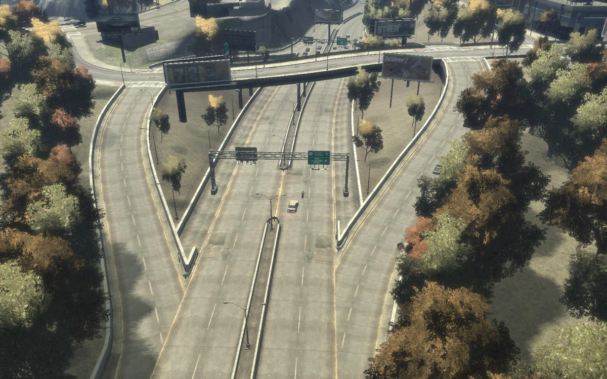
The Algonquin - Dukes Expressway is a 1.9 mile freeway that connects Algonquin to Dukes in Liberty City in Grand Theft Auto IV and Grand Theft Auto: Chinatown Wars, with three intersections in Liberty City. It connects Algonquin Bridge with the Francis International Airport via northern Broker and southern Dukes.
Of all the Expressways in Liberty City, the Algonquin-Dukes Expressway possesses the most freeway-like features, with sophisticated exit/entrance infrastructure and isolation from road networks. It is also the only expressway with hard shoulders. Other Expressways do possess these features, but not for their full lengths.
It is most likely based on the Midtown-Queens Expressway being part of the Long Island Expressway in New York City. The fact that Algonquin Bridge carries the expressway is based on the planned-but-unbuilt Lower Manhattan Expressway.
Length
The length of the Algonquin-Dukes Expressway is of 1.9 mile from the Lancet entrance/exit to the end of the loop the highway performs aound the parking lot of Francis International Airport.
Exits and Entrances
The freeway travels West - East from the Lancet, Midtown Algonquin to Francis International Airport, Dukes Albany Avenue intersection. There are four exits/entrances between these two terminals.
Midtown Algonquin
1. K Street/B Ave Intersection - Lancet
Entrance and Exit available from this intersection.
The freeway extends east across the Algonquin Bridge over Colony Island from this intersection. There is about a mile of road before the second intersection.
Northbound, Southbound and Westbound exits are available from this intersection.
2. Montauk Ave/Munsee Ave- Downtown (Exit 1)
Entrance and exit available from this intersection.
Upon reaching the Broker coastline the freeway is elevated over the districts of BOABO and Rotterdam Hill before it extends over the Broker Bus Terminal and Montauk Avenue in Downtown. Four slip roads allow entrance and exit in both directions, bringing drivers down to street level. The two entrance roads are located along Montauk Avenue as is the Westbound exit road, the Eastbound exit road however brings drivers slightly further West onto Munsee Avenue.
This intersection is a very important transport link for residents of Western Broker and Dukes as it is positioned very close to the two borough's boundaries and serves as their primary means of accessing Midtown Algonquin. It is particularly conveniently positioned for residents of Schottler, Cerveza Heights, Rotterdam Hill, BOABO and Outlook.
3. Saratoga Avenue/Broker-Dukes Expressway - Beechwood City (Exit 2) Entrance and exit available from this intersection.
The freeway travels further east through Schottler, gradually decreasing its gradient as it passes over the Broker-Dukes Tunnel and briefly enters the Cerveza Heights neighborhood of Dukes. The freeway then begins falling below street level into a small valley. The freeway now passes under Stillwater Ave before re-entering Broker and Beechwood City. The freeway's third intersection is located here.
Similar to the second intersection, entrance and exit is provided to and from the freeway here by four slip roads; as the freeway is below-grade however, the slip roads elevate rather than slope downwards. The four roads provide access to a fairly green part of Beechwood City along Saratoga Avenue. Travelling south along Saratoga Avenue provides almost immediate access to intersection 9 of the Broker-Dukes Expressway whereas travelling north along the Avenue will cross you over the Dukes border into the thriving Willis district.
This intersection is not as busy as the Downtown intersection but is an important transport link for residents of Eastern Broker and Dukes. It is particularly conveniently positioned for residents of Beechwood City, Willis and Meadow Hills.
4. Francis International Airport/Broker-Dukes Expressway (Exit 3) - Francis Internationl Airport Entrance and Exit available from this intersection.
Very soon after intersection three, the freeway enters the Dukes district of Francis International Airport. This intersection marks the meeting point of the Algonquin-Dukes Expressway and the Broker-Dukes Expressway and is the largest intersection in Liberty City.
Access to the Broker-Dukes Expressway is provided by elevating slip roads. Reaching the Broker-Dukes Expressway from the eastbound Algonquin-Dukes Expressway is performed by using either of the slip roads. Using the first slip road, which extends out from the right, will allow drivers to join the southbound Broker - Dukes Expressway, whereas using the sliproad that extends out from the left after passing under the Expressway will allow drivers to join the northbound Broker-Dukes Expressway. Using neither of these sliproads and continuing along the freeway will result in the driver joining the Airport Ring Road, which provides access to various parts of Francis International. This marks the eastern terminus of the Algonquin-Dukes Expressway.
Traffic
Traffic is light throughout the Expressway.