(Adding categories) |
MonkeyBot188 (talk | contribs) m (→Navigation: category update) |
||
| (39 intermediate revisions by 13 users not shown) | |||
| Line 1: | Line 1: | ||
| + | {{Infobox road |
||
| − | '''Exeter Ave''' is one of [[Algonquin]]'s seven North-South avenues. It serves the inner west side of Algonquin extending for 13 blocks, making it the shortest avenue in [[Algonquin]]. It's based on New York's [[wp:Seventh Avenue|Seventh Avenue]]. Despite its short length, it travels further north than any other avenue, starting from the intersection with Grummer Road along the north coast. The road travels south through [[Northwood]] and [[East Holland]] before reaching the boundary with [[Middle Park]] on [[Topaz Street]]. The large middle park disallows Exeter Avenue from continuing further, therefore the avenue re-emerges from Nickel Street along the [[Middle Park]] and [[Star Junction]] boundaries on the other side of the park. The Avenue is now fused with [[Denver Ave]] to form the [[Denver-Exeter Avenue]]. The avenue becomes double sized, with four lanes of traffic in a purely southbound direction. The combined avenue travels south for seven blocks through the [[Star Junction]] and [[The Triangle]] districts. Upon reaching Garnet Street at [[The Triangle]] and [[Suffolk]] borders the [[Denver-Exeter Avenue|Denver-Exeter]] and Exeter Avenues terminate, whilst Denver Avenue continues further south. |
||
| + | |image = |
||
| + | <gallery> |
||
| + | ExeterAvenue-GTAIV-South.jpg|North |
||
| + | ExeterAvenue-GTAIV-North.jpg|South |
||
| + | </gallery> |
||
| + | |games = ''[[Grand Theft Auto IV]]''<br>''[[Grand Theft Auto: Chinatown Wars]]'' |
||
| + | |start = [[Grummer Road]] in [[Northwood]] |
||
| + | |end = [[Topaz Street]] in [[Middle Park]] |
||
| + | |pscanner = <ref name="policescanner">Unlike other avenues of [[Algonquin]], Exeter Avenue does not have a police scanner audio file.</ref> |
||
| + | |map = ExeterAvenue-GTAIV-Map.png |
||
| + | |mapcaption = Location on the map (red) in ''[[Grand Theft Auto IV]]''. |
||
| + | |map2 = ExeterAvenue-GTACW-Map.png |
||
| + | |mapcaption2 = Location on the map (red) in ''[[Grand Theft Auto: Chinatown Wars]]''. |
||
| + | }} |
||
| + | '''Exeter Avenue''' is an [[List of Street Names|avenue]] in ''[[Grand Theft Auto IV]]'' and ''[[Grand Theft Auto: Chinatown Wars]]'', located in [[Algonquin]], [[Liberty City (HD Universe)|Liberty City]]. |
||
| + | ==Description== |
||
| − | The street could be named after a [[wp:Exeter (disambiguation)|collection of towns]] named after the [[wp:Exeter|historic city, of the same name]] in [[wp:Devon|Devon, England]]. |
||
| + | The avenue starts in the north at an intersection with [[Grummer Road]] in [[Northwood]], and runs directly south, passing through the areas of [[East Holland]] and [[Middle Park]]. |
||
| + | Exeter Avenue terminates at the northern fringe of [[Middle Park]], but does serve as part of [[Denver-Exeter Avenue]] - [[Denver Avenue]] merging with Exeter Avenue as it passes through the [[Star Junction]] region where it crosses paths with [[Burlesque]]. Unlike Denver Avenue, Exeter Avenue does not continue in its own name, partially due to the fact Algonquin island narrows in its southern half, however other smaller streets and passages take its place between [[Denver Avenue]] and [[Frankfort Avenue]]. |
||
| − | {{GTA IV Avenues}} |
||
| + | |||
| ⚫ | |||
| + | [[File:NorthwoodFireStation-GTAIV.png|thumb|270px|right|[[Northwood Fire Station]].]] |
||
| ⚫ | |||
| + | Its short span naturally means less landmarks are present, however it does look out onto [[Middle Park]] due to its area's height compared to the rest of Algonquin. The [[Northwood Fire Station]] is also found along the road. It also connects with [[Frankfort Avenue]] - being the only avenue to connect with another avenue (excluding the name-merged Denver-Exeter Avenue), where the [[Northwood Heights Bridge]] starts and crosses the [[Humboldt River]]. The [[Algonquin Inner Line|Algonquin Inner Line (K/B)]]-[[Bohan Line|Bohan Line (E/B)]] passes over the road as it crosses the [[Humboldt River]] parallel to the Northwood Heights Bridge, east-bound towards the [[San Quentin Avenue Station]] (E/B on Bohan Line) and west-bound towards the [[Frankfort High Station]] (K/B on Algonquin Inner Line). |
||
| + | |||
| + | [[File:ExeterAvenue-GTAIV-MoviePit.jpg|thumb|right|270px|[[Movie Pit]] cinema.]] |
||
| + | Along the road are various low to medium-end businesses. An accessible [[Cluckin' Bell]] as well as a [[Modo]] branch are also found on the road. The [[Movie Pit]] cinema is also found on the road. |
||
| + | |||
| + | The northern span of the road passes through the Northwood project apartments before it descends close to water level near the waterfront, connecting with [[Grummer Road]]. |
||
| + | |||
| + | The entire street is a 2-lane road flowing in both directions and connects to 6 streets, namely [[Grummer Road]], and as 5 other streets of [[Algonquin]]'s [[List of Street Names|alphabetical system]], including [[Topaz Street|T]], [[Uranium Street|U]], [[Vauxite Street|V]] and [[Wardite Street|W]] and [[Xenotime Street|X]], missing out A-S. |
||
| + | |||
| + | Unlike other [[Algonquin]] avenues, Exeter Avenue lacks a [[Dialogues in GTA IV#Police Scanner|police scanner]] audio file.<ref name="policescanner"/> |
||
| + | |||
| + | Exeter Avenue's placement as one of two avenues between [[Middle Park]] suggests it is based on {{WP|Seventh Avenue}} in Manhattan, New York City. |
||
| + | |||
| + | {{Clr}} |
||
| + | ==Intersections== |
||
| + | {| class="wikitable" |
||
| + | !Location |
||
| + | !Type |
||
| + | !Road |
||
| + | !Direction |
||
| + | !Image(s) |
||
| + | |- |
||
| + | | rowspan="1"|[[Middle Park]] |
||
| + | |{{jmark|rb}} |
||
| + | |[[Topaz Street]] |
||
| + | |e/b towards [[Union Drive East]] and [[Albany Avenue]].<br />w/b towards [[Hickey Bridge]]. |
||
| + | |[[File:ExeterAvenue-GTAIV-TopazStreet.jpg|thumb|center|220px]] |
||
| + | |- |
||
| + | | rowspan="2"|[[East Holland]] |
||
| + | |{{jmark}} |
||
| + | |[[Uranium Street]] |
||
| + | |w/b towards [[Galveston Avenue]].<br />e/b towards [[Bismarck Avenue]]. |
||
| + | |[[File:ExeterAvenue-GTAIV-UraniumStreet.jpg|thumb|center|220px]] |
||
| + | |- |
||
| + | |{{jmark}} |
||
| + | |[[Vauxite Street]] |
||
| + | |w/b towards [[Ivy Drive North]].<br />e/b towards [[Bismarck Avenue]] and [[San Juan Road]]. |
||
| + | |[[File:ExeterAvenue-GTAIV-VauxiteStreet.jpg|thumb|center|220px]] |
||
| + | |- |
||
| + | | rowspan="3"|[[Northwood]] |
||
| + | |{{jmark}} |
||
| + | |[[Xenotime Street]] |
||
| + | |w/b towards [[Galveston Avenue]].<br />e/b towards [[Vespucci Circus]]. |
||
| + | |[[File:ExeterAvenue-GTAIV-XenotimeStreet.jpg|thumb|center|220px]] |
||
| + | |- |
||
| + | |{{jmark}} |
||
| + | |[[Frankfort Avenue]] & [[Northwood Heights Bridge]] |
||
| + | |w/b towards [[Union Drive West]].<br />e/b towards [[Northwood Heights Bridge]]. |
||
| + | |[[File:ExeterAvenue-GTAIV-FrankfortAvenue.jpg|thumb|center|220px]] |
||
| + | |- |
||
| + | |{{jmark|re}} |
||
| + | |[[Grummer Road]] |
||
| + | |w/b towards [[Ivy Drive North]].<br />e/b towards [[Walnut Way]]. |
||
| + | |[[File:ExeterAvenue-GTAIV-GrummerRoad.jpg|thumb|center|220px]] |
||
| + | |} |
||
| + | |||
| + | ==Notable Landmarks== |
||
| + | *[[Northwood Fire Station]] <small>(between [[Xenotime Street]] and [[Frankfort Avenue]])</small> |
||
| + | *[[Northwood Heights Bridge]] <small>(continuation of [[Frankfort Avenue]])</small> |
||
| + | |||
| + | ==Notable Businesses== |
||
| + | *[[Classy Sassy]] |
||
| + | *[[Cluckin' Bell]] |
||
| + | *[[Holland]] |
||
| + | *[[Minoan Unisex]] |
||
| + | *[[Movie Pit]] |
||
| + | *[[Modo]] <small>(corner of Vauxite Street)</small> |
||
| + | *[[Spoon Up]] |
||
| + | |||
| + | ==Gallery== |
||
| + | <gallery position="center" spacing="small" widths="270px"> |
||
| + | ExeterAvenue-GTAIV-Night.jpg|The street at night. |
||
| + | ExeterAvenue-GTAIV-Alleyway.jpg|An alleyway opposite [[Northwood Fire Station]], leading to [[Vespucci Circus]]. |
||
| + | ExeterAve_GTACW.jpg|'''Exeter Avenue''' in ''[[Grand Theft Auto: Chinatown Wars]]''. |
||
| + | </gallery> |
||
| + | |||
| + | ==Trivia== |
||
| + | *Like other avenues of [[Algonquin]], Exeter Avenue is named after a state capital of the [[United States]], specifically the former state capital {{WP|Exeter, New Hampshire|Exeter}}, {{WP|New Hampshire|New Hampshire}}. |
||
| + | |||
| + | ==References== |
||
| + | {{Reflist}} |
||
| + | |||
| + | ==Navigation== |
||
| + | {{Navboxes |
||
| + | |title= Navigation |
||
| + | |list1= |
||
| + | {{gtaiv roads|state=collapsed}} |
||
| + | }} |
||
| + | [[Category:Structures in GTA IV in Algonquin|Avenue, Exeter]] |
||
| ⚫ | |||
| ⚫ | |||
Latest revision as of 19:44, 9 April 2024
Exeter Avenue is an avenue in Grand Theft Auto IV and Grand Theft Auto: Chinatown Wars, located in Algonquin, Liberty City.
Description
The avenue starts in the north at an intersection with Grummer Road in Northwood, and runs directly south, passing through the areas of East Holland and Middle Park.
Exeter Avenue terminates at the northern fringe of Middle Park, but does serve as part of Denver-Exeter Avenue - Denver Avenue merging with Exeter Avenue as it passes through the Star Junction region where it crosses paths with Burlesque. Unlike Denver Avenue, Exeter Avenue does not continue in its own name, partially due to the fact Algonquin island narrows in its southern half, however other smaller streets and passages take its place between Denver Avenue and Frankfort Avenue.

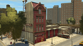
Its short span naturally means less landmarks are present, however it does look out onto Middle Park due to its area's height compared to the rest of Algonquin. The Northwood Fire Station is also found along the road. It also connects with Frankfort Avenue - being the only avenue to connect with another avenue (excluding the name-merged Denver-Exeter Avenue), where the Northwood Heights Bridge starts and crosses the Humboldt River. The Algonquin Inner Line (K/B)-Bohan Line (E/B) passes over the road as it crosses the Humboldt River parallel to the Northwood Heights Bridge, east-bound towards the San Quentin Avenue Station (E/B on Bohan Line) and west-bound towards the Frankfort High Station (K/B on Algonquin Inner Line).

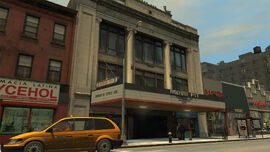
Movie Pit cinema.
Along the road are various low to medium-end businesses. An accessible Cluckin' Bell as well as a Modo branch are also found on the road. The Movie Pit cinema is also found on the road.
The northern span of the road passes through the Northwood project apartments before it descends close to water level near the waterfront, connecting with Grummer Road.
The entire street is a 2-lane road flowing in both directions and connects to 6 streets, namely Grummer Road, and as 5 other streets of Algonquin's alphabetical system, including T, U, V and W and X, missing out A-S.
Unlike other Algonquin avenues, Exeter Avenue lacks a police scanner audio file.[1]
Exeter Avenue's placement as one of two avenues between Middle Park suggests it is based on Seventh Avenue in Manhattan, New York City.
Intersections
| Location | Type | Road | Direction | Image(s) |
|---|---|---|---|---|
| Middle Park | Topaz Street | e/b towards Union Drive East and Albany Avenue. w/b towards Hickey Bridge. |
||
| East Holland | Uranium Street | w/b towards Galveston Avenue. e/b towards Bismarck Avenue. |
||
| Vauxite Street | w/b towards Ivy Drive North. e/b towards Bismarck Avenue and San Juan Road. |
|||
| Northwood | Xenotime Street | w/b towards Galveston Avenue. e/b towards Vespucci Circus. |
||
| Frankfort Avenue & Northwood Heights Bridge | w/b towards Union Drive West. e/b towards Northwood Heights Bridge. |
|||
| Grummer Road | w/b towards Ivy Drive North. e/b towards Walnut Way. |


Notable Landmarks
- Northwood Fire Station (between Xenotime Street and Frankfort Avenue)
- Northwood Heights Bridge (continuation of Frankfort Avenue)
Notable Businesses
- Classy Sassy
- Cluckin' Bell
- Holland
- Minoan Unisex
- Movie Pit
- Modo (corner of Vauxite Street)
- Spoon Up
Gallery
")
")
")
Trivia
- Like other avenues of Algonquin, Exeter Avenue is named after a state capital of the United States, specifically the former state capital Exeter, New Hampshire.