(Undo revision 628975 by Cloudkit01 (talk) McJeff said not to) |
Tags: Visual edit apiedit |
||
| (9 intermediate revisions by 6 users not shown) | |||
| Line 1: | Line 1: | ||
| − | [[Image:FlintIntersection.jpg|thumb|300px|right|The Flint Intersection, just west of [[Los Santos]], [[State of San Andreas|San Andreas]]]] |
+ | [[Image:FlintIntersection.jpg|thumb|300px|right|The Flint Intersection, just west of [[Los Santos (3D Universe)|Los Santos]], [[State of San Andreas (3D Universe)|San Andreas]].]] |
| − | The '''Flint Intersection''' is a major highway/road intersection connecting the main road servicing southern [[Los Santos (3D Universe)|Los Santos]] and [[Flint County]] with the major highway servicing Los Santos and [[San Fierro]], running through Flint County and [[Whetstone]]. The intersection is located just west of the [[Richman (3D Universe)|Richman]] district of Los Santos, and north of the [[Los Santos Inlet]] |
+ | The '''Flint Intersection''' is a major highway/road intersection connecting the main road servicing southern [[Los Santos (3D Universe)|Los Santos]] and [[Flint County]] with the [[San Fierro Highway|major highway]] servicing Los Santos and [[San Fierro (3D Universe)|San Fierro]], running through Flint County and [[Whetstone]]. The intersection is located just west of the [[Richman (3D Universe)|Richman]] district of Los Santos, and north of the [[Los Santos Inlet]]. |
| − | + | Also, some bug lets all the traffic leave the highway at the intersection and the tunnel isn't used at all. |
|
==Layout== |
==Layout== |
||
The intersection is very limited and can be classed as "incomplete". There are only two loops, serving cars coming from the west ([[Angel Pine]] and west San Fierro) going to the north, and those coming from the south ([[Los Santos (3D Universe)|Los Santos]]) going to the west. There are no roads serving any other directions. |
The intersection is very limited and can be classed as "incomplete". There are only two loops, serving cars coming from the west ([[Angel Pine]] and west San Fierro) going to the north, and those coming from the south ([[Los Santos (3D Universe)|Los Santos]]) going to the west. There are no roads serving any other directions. |
||
| + | |||
The intersection resembles a cloverleaf intersection with the edge roads and two loops removed. The region also includes a trailer park where a [[Monster]] is parked. |
The intersection resembles a cloverleaf intersection with the edge roads and two loops removed. The region also includes a trailer park where a [[Monster]] is parked. |
||
==The Suicidal Photographer== |
==The Suicidal Photographer== |
||
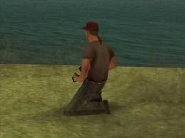
| + | [[File:SuicidalPhotographer-GTASA.jpg|thumb|220x220px|The photographer in a kneeling position. ]] |
||
| − | <p style="text-align: center">''For Myths see [http://www.gta-myths.wikia.com GTA Myths Wiki].''</p> |
||
| + | Across the road to the south of the trailer park, a random [[Pedestrians|pedestrian]] will often be seen shooting photographs of the Los Santos skyline across the inlet. This involves some detailed animation: the pedestrian is shown both standing erect and kneeling, holding a [[camera]] up to his/her face, clicking the shutter (which is heard), and a camera flash is also seen. If the player observes the pedestrian for a while, eventually he/she will stop taking photos, sometimes will utter a random phrase or greeting to [[Carl Johnson|Carl]], and then walk away right into the water, where the photographer drowns. |
||
| − | + | Contrary to common belief, the suicidal photographer is not an [[Easter Eggs in GTA San Andreas|easter egg]] and actually a programming mishap - pedestrians in the game usually follow predetermined paths, and the lack of one nearby causes one to walk off to wherever he/she is facing; in this case, the water. |
|
==Weapons== |
==Weapons== |
||
| Line 18: | Line 20: | ||
==Stationary Vehicles== |
==Stationary Vehicles== |
||
*[[Bobcat]] |
*[[Bobcat]] |
||
| + | *[[Freeway]] (sometimes replaced by [[Sanchez]]) |
||
*[[Monster]] |
*[[Monster]] |
||
*[[Tractor]] (at night only) |
*[[Tractor]] (at night only) |
||
| + | ==Navigation== |
||
{{GTASA Rural Areas}} |
{{GTASA Rural Areas}} |
||
Revision as of 21:48, 27 September 2015
The Flint Intersection, just west of Los Santos, San Andreas.
The Flint Intersection is a major highway/road intersection connecting the main road servicing southern Los Santos and Flint County with the major highway servicing Los Santos and San Fierro, running through Flint County and Whetstone. The intersection is located just west of the Richman district of Los Santos, and north of the Los Santos Inlet.
Also, some bug lets all the traffic leave the highway at the intersection and the tunnel isn't used at all.
Layout
The intersection is very limited and can be classed as "incomplete". There are only two loops, serving cars coming from the west (Angel Pine and west San Fierro) going to the north, and those coming from the south (Los Santos) going to the west. There are no roads serving any other directions.
The intersection resembles a cloverleaf intersection with the edge roads and two loops removed. The region also includes a trailer park where a Monster is parked.
The Suicidal Photographer
The photographer in a kneeling position.
Across the road to the south of the trailer park, a random pedestrian will often be seen shooting photographs of the Los Santos skyline across the inlet. This involves some detailed animation: the pedestrian is shown both standing erect and kneeling, holding a camera up to his/her face, clicking the shutter (which is heard), and a camera flash is also seen. If the player observes the pedestrian for a while, eventually he/she will stop taking photos, sometimes will utter a random phrase or greeting to Carl, and then walk away right into the water, where the photographer drowns.
Contrary to common belief, the suicidal photographer is not an easter egg and actually a programming mishap - pedestrians in the game usually follow predetermined paths, and the lack of one nearby causes one to walk off to wherever he/she is facing; in this case, the water.