No edit summary |
No edit summary |
||
| Line 3: | Line 3: | ||
|image= [[File:LosSantosPics.png|right]] |
|image= [[File:LosSantosPics.png|right]] |
||
|mayor= |
|mayor= |
||
| − | |pop= |
+ | |pop=4,000,000+ (Santosinos) |
|established=1781 |
|established=1781 |
||
|state= [[San Andreas in HD Universe|San Andreas]] |
|state= [[San Andreas in HD Universe|San Andreas]] |
||
Revision as of 02:41, 22 October 2013
Los Santos is a fictional city located in the southwestern United States in Los Santos County within the State of San Andreas in Grand Theft Auto V. GTA V is the city's 2nd appearance in the series after GTA San Andreas. Los Santos is based on Los Angeles, California, and its greater metropolitan area. Los Santos is Spanish for "The Saints", a play on "The Angels".
Like its real-life counterpart of LA, Los Santos is a huge sprawling metropolis with a lot of cultures, the film-making industry and the hood life, just to name a couple. Not unlike Liberty City in GTA IV, the time and date of the city is present of the year the game was released. GTA V's rendition of Los Santos is divided into the sections of North Los Santos, East Los Santos, West Los Santos and South Los Santos, in which beneath the sections the streets are divided into districts or neighborhoods, and one incorporated city.
The city is served by the Los Santos International Airport, which is one of the busiest airports in the world. Los Santos also has an extensive transit system.
The city was first revealed in the debut trailer of GTA V.
Landmarks and Sightings
- Mile High Club
- Maze Bank Arena (Great Western Forum)
- Los Santos Country Club (Los Angeles Country Club)
- Vinewood Sign (Hollywood Sign)
- Maze Bank Tower (US Bank Tower)
- Sightings Bar & Restaurant (Theme Building)
- Badger Building (Capitol Records Building)
- Arcadius Business Center (Westin Bonaventure Hotel)
- Los Santos City Hall (Los Angeles City Hall)
- Pegasus Concierge Hotel (Sunset Tower Hotel )
- Standard Hotel look alike
- 801 Tower look alike
- Puerta del Sol Yacht Club (Marina City Club)
- Lombank Building (100 Wilshire Building)
- Rockford Hills City Hall (Beverly Hills City Hall)
- Rockford Plaza (Beverly Center)
- Von Crastenberg Richman (Beverly Hilton)
- Vinewood Bowl (Hollywood Bowl)
- Weazel Plaza (Fox Plaza)
- FIB Headquarters (One California Plaza)
- IAA Headquarters (Two California Plaza)
- Schlongberg Sachs Center (Citigroup Center)
- Union Depository Tower
- Rockford Dorset Hotel (Beverly Wilshire Hotel)
- WIWANG Tower
- Dream Tower
- Opium Nights Hotel
Air and Sea Ports
- Los Santos International Airport (Los Angeles International Airport)
- Port of Los Santos (Port of Los Angeles)
Districts/Neighborhoods
Central Los Santos


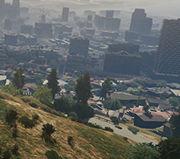
Central Los Santos from air.
Central Los Santos districts make up the area of Downtown Los Santos. The area is bounded by the Del Perro Freeway to the north, the La Puerta freeway to the west, the Olympic Freeway to the south and the Los Santos River to the east. The area is chracterised as Los Santos' most urbanised area, with the presence of the tallest high-rises.
- Downtown Los Santos (Downtown)
- Textile City (Fashion District)
- Mission Row (Skid Row)
- Pillbox Hill (Bunker Hill)
- Legion Square (Pershing Square)
North Los Santos
North Los Santos comprises the neighborhoods that extend north from Downtown Los Santos into the Vinewood Hills at the northern fringes of the city. The area is suburban in nature and possesses Los Santos' most affluent and exclusive neighborhoods.

- Alta (Los Feliz)
- Burton (Beverly Grove)
- Rockford Hills (Beverly Hills)
- Vinewood (Hollywood)
- Richman (Bel Air)
- West Vinewood (West Hollywood)
- Vinewood Hills (Hollywood Hills)
- Downtown Vinewood (Downtown Hollywood)
- Hawick (Melrose)
South Los Santos
South Los Santos includes the neighborhoods or areas that define as independent cities that extend south from Downtown Los Santos. The south of the city is home to Los Santos' poorest residents. The south-central districts has several low-income housing projects and garbage pilling up the streets. The city of Davis also lays in this area. South Los Santos is mostly based of South Los Angeles, as well as the city of Long Beach. The port and docks of Los Santos is defined also as South Los Santos.


- Strawberry (Inglewood)
- Davis (Compton)
- Rancho (Watts)
- Chamberlain Hills (Baldwin Hills/Crenshaw)
- La Puerta (San Pedro)
- Los Santos International Airport (Los Angeles International Airport)
- Banning (Wilmington)
- Elysian Island (Terminal Island)
- Cypress Flats(Long Beach)
- Terminal (Long Beach Harbor)
East Los Santos
East Los Santos comprises the neighborhoods bounded between the Los Santos Freeway and the Los Santos River to the west and the Tataviam and Palomino Highlands mountain ranges to the east. The area sees considerable disparities of wealth, with northern districts (e.g. East Vinewood and Mirror Park) being home to the elite and middle classes, districts in central east Los Santos (e.g. El Burro Heights, Murrieta Heights, La Mesa) possessing working class residents and southern districts being home to many of Los Santos' harsh industrial facilities.
- East Vinewood (East Hollywood)
- Mirror Park (Echo Park, Silver Lake)
- East Los Santos (East Los Angeles)
- La Mesa (El Sereno)
- El Burro Heights (Signal Hill)
- Murrieta Heights (Boyle Heights)
- Cypress Flats (Long Beach)
- Murrieta Oil Field (Long Beach Oil Fields)
West Los Santos
West Los Santos comprises the neighborhoods that sprawl west from Downtown Los Santos, extending as far as the Pacific Bluffs, at the city's western limits. Whilst not as affluent as North Los Santos, neighborhoods in the west of the city generally still possess high levels of wealth.
- Little Seoul (Koreatown)
- Morningwood (Westwood)
- Del Perro (Santa Monica)
- Pacific Bluffs (Pacific Palisades/Malibu Bluffs Park)
- Backlot City (Culver City)
- La Puerta ( San Pedro)
- Vespucci Canals (Venice Canals)
- Vespucci (Venice Beach)
Highways/Streets
- La Puerta Freeway (Harbor Freeway)
- Elysian Fields Freeway
- Los Santos Freeway
- Del Perro Freeway (Santa Monica Freeway)
- Olympic Freeway
- Palomino Freeway
- Senora Freeway
- Great Ocean Highway (East Pacific Coast Highway)
- Los Santos Freeway
- Mountain View Drive
- Jamestown Ave
- Dutch London St
- Portola Drive (Rodeo Drive)
- Bay City Ave
- W. Elipse Blvd
- South Rockford Drive
- Panorama Drive
- Nikola Avenue
- Forum Drive
- Carson Avenue
- Vespucci Boulevard
- Strawberry Ave
- Jamestown St
- Vinewood Boulevard
- Grove Street
Transportation
Los Santos offers a wide range of transportation, including a connected major highway system, and several other smaller highways, with several exits and on-ramps around the city. The city also has its own rapid transit system named the Los Santos Transit. Buses can also be seen spawned in traffic all around the city. Like most cities, Los Santos traffic is monitored and controlled by the Los Santos Transport Traffic Control System which allows the city to control traffic lights and manipulate conditions and the flow of vehicles on the streets and highways.
Mountain Ranges
- Tataviam Mountains (San Gabriel Mountains)
- Palomino Highlands (Chino Hills)
- Vinewood Hills (Hollywood Hills)
- Banham Canyon (Topanga Canyon)
- Tongva Hills (Agoura Hills)
- Tongva Valley (San Fernando Valley)
- Great Chaparral (Angeles National Forest)
Law Enforcement
Main article: LSPD in HD Universe

The Los Santos Police Department (LSPD) is the law enforcement agency that serves Los Santos, along with the Los Santos County Sheriff's Department. Their motto is "Obey & Survive", which is inscripted on their squad cars. Unlike the LCPD, they use newer Vapid Police Cruisers and also use Vapid Interceptor, as apposed to the Merit-based Police Patrol , but they still use the Police Maverick as their main squad and helicopter units respectively.
Healthcare
- Central Los Santos Medical Center
- Mount Zonah Medical Center (Cedars-Sinai Medical Center)
- Pillbox Hill Medical Center (California Hospital Medical Center)
- St. Fiacre Teaching Hospital
- Eclipse Medical Tower (Sunset Medical Tower)
Art and Culture
- Betsy O'Neal Pavilion (Dorothy Chandler Pavilion)
- Doppler Cinema
- Oriental Theater (TCL Chinese Theater)
- Sisyphus Theater
- Ten Cent Theater
- Tivoli Cinema (Fox Bruin Theater)
- Valdez Theater (Wiltern Theater)
Gallery
")
")
")
")
")
")
")
")
Trivia
- On November 3rd of 2011, Rockstar Games revealed that Los Santos' Grand Theft Auto V rendition will be bigger and contain rural areas, valleys, and beaches. (Source)
- After travelling long enough in GTA IV the stats will record miles traveled from Liberty City to Los Santos.
- The pedestrian stop/start walk signs show a man strutting.
- Los Santos is the first city in the GTA series with an elementary school and high school.
- Los Santos is the only city in the HD Universe with highways wider than four lanes.
- Los Santos in the HD Universe has the highest sky limit than any other GTA game in the 3D and HD Universes.
- During nighttime, the sky turns into a dark yellow colour. However, as soon as the player exits the city, the sky turns back to normal. This is a reference to how polluted Los Angeles is due to the smog covering the skies.
| Grand Theft Auto V | |
|---|---|
| Locations | State of San Andreas (Los Santos (County) and Blaine County) | State of North Yankton (Ludendorff) |
| Characters | Michael De Santa | Trevor Philips | Franklin Clinton | Lamar Davis | Amanda De Santa | Jimmy De Santa | Tracey De Santa | Chop | Simeon Yetarian | Martin Madrazo | Lester Crest | Ron Jakowski | Wade Hebert | Dave Norton | Steve Haines | Devin Weston | Stretch | Wei Cheng |
| Content | Missions | Strangers and Freaks | Random Events | Vehicles | Weapons | Properties | Safehouses | Characters | Clothing | Tattoo Parlors | Radio Stations | Internet | TV Shows |
| Information | 100% Completion | Achievements/Trophies | Cheats | Trailers | Screenshots | Artworks | Snapmatic | Rockstar Editor | Grand Theft Auto Online |