Nebiksrazu (talk | contribs) No edit summary |
Kevinbgc1997 (talk | contribs) (→Route) Tag: sourceedit |
||
| (8 intermediate revisions by 3 users not shown) | |||
| Line 1: | Line 1: | ||
| − | [[Image:HighwayMorning.jpg|thumb|250px|right|The |
+ | [[Image:HighwayMorning.jpg|thumb|250px|right|The San Fierro Highway]] |
| − | The ''' |
+ | The '''San Fierro Highway ''' is a highway in the [[San Andreas (3D Universe)|San Andreas]]. It runs a similar route to [[wp:California State Route 1|State Route 1]] in real life San Francisco. It starts in the [[Rodeo]] district of [[Los Santos (3D Universe)|Los Santos]], terminating at an intersection [[San Fierro (3D Universe)|San Fierro]] connecting to [[Easter Basin]], [[Doherty]], [[Foster Valley]] and the [[San Fierro Bypass|highway]] servicing the [[Garver Bridge]]. It passes through the eastern and south edges of [[Flint County]], as well as the southern edge of [[Whetstone]]. It also has an [[Flint Intersection|intersection]] with another major road in Flint County and Los Santos, providing access to [[Santa Maria Beach]] and [[Flint Range]], while another intersection exists servicing the town of [[Angel Pine]]. The highway has five tunnels towards San Fierro, but only four on the way back to Los Santos. Mostly, the highway is separated into two roads (one for each direction), however there are times when they meet together, although there are no cement dividers to keep traffic to its own side. Like most other countryside highways, the San Fierro Highway lacks illumination from lampposts (except when it is in San Fierro and Angel Pine), with only small poles at some sections which reflect the car's headlights. Thus, it is far preferable to drive on the highway only during daytime, however, some players may seek fast transport, and so the San Fierro Highway may be the only option. Three highway stops can be found along the highway; one stop has a [[Xoomer|gas station]] and a [[24/7]] in it. |
==Route== |
==Route== |
||
| − | The San Fierro Highway starts at an intersection on the [[Mulholland Drive]] in northern [[Rodeo]], and immediately enters a tunnel passing underneath [[Richman (3D Universe)|Richman]]. After that it passes the [[Flint Intersection]], however this is only a partial intersection, and thus, only eastbound traffic can use it to get to [[Red County]]. The highway then turns south, going through the eastern sections of [[Back O' Beyond]]. It follows the east of Back O' Beyond and south edge of [[Flint County]] and [[Whetstone]], passing a [[24/7]], gas station and [[Angel Pine]]. It then enters two short tunnels underneath [[Mount Chiliad (3D Universe)|Mount Chiliad]] and after the [[Whetstone Bridge]] it enters the southwest section of [[San Fierro (3D Universe)|San Fierro]]. The expressway ends at an intersection servicing [[Missionary Hill]] and it becomes a major road through San Fierro. The highway turns east towards the [[Easter Bay Airport]] and has an exit to the [[Corvin Stadium|stadium]] and [[Doherty]]. It finally ends at the intersection servicing the [[San Fierro Bypass]]. |
+ | The San Fierro Highway starts at an intersection on the [[Mulholland Drive]] in northern [[Rodeo]], and immediately enters a tunnel passing underneath [[Richman (3D Universe)|Richman]]. After that it passes the [[Flint Intersection]], however this is only a partial intersection, and thus, only eastbound traffic can use it to get to [[Red County]]. The highway then turns south, going through the eastern sections of [[Back O' Beyond]]. It follows the east of Back O' Beyond and south edge of [[Flint County]] and [[Whetstone]], passing a [[24/7]], gas station and [[Angel Pine]]. It then enters two short tunnels underneath [[Mount Chiliad (3D Universe)|Mount Chiliad]] and after the [[Whetstone Bridge]] it enters the southwest section of [[San Fierro (3D Universe)|San Fierro]]. The expressway ends at an intersection servicing [[Missionary Hill]] and it becomes a major road through San Fierro. The highway turns east towards the [[Easter Bay International Airport]] and has an exit to the [[Corvin Stadium|stadium]] and [[Doherty]]. It finally ends at the intersection servicing the [[San Fierro Bypass]]. |
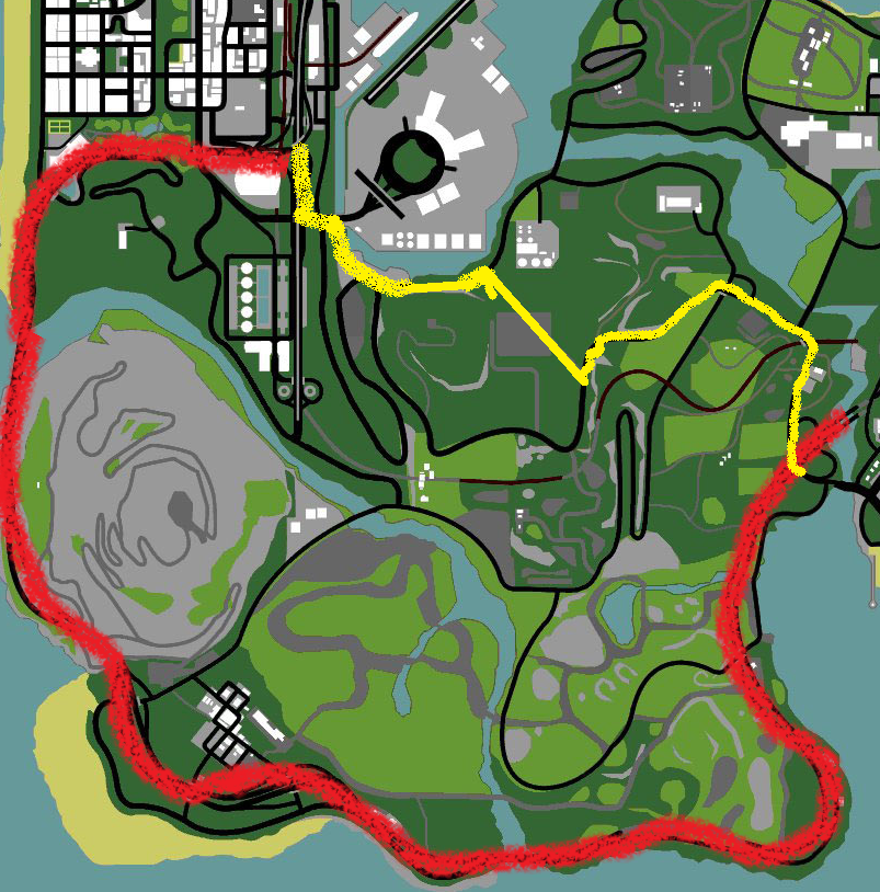
| − | The route is indirect. Instead of cutting through Flint County, making a straight line. Instead, it just makes a partial loop and runs on the coast making it the shape of a U. The highway is |
+ | The route is indirect. Instead of cutting through Flint County, making a straight line. Instead, it just makes a partial loop and runs on the coast making it the shape of a U. The highway is obviously based off US Route 1 running up the coast from Los Angeles to San Francisco. Here is a map of a shortcut route.[[File:Shortcut.png|thumb|The red line is the San FIerro Freeway, the yellow line is the shortcut route, Going by the truck depot and through the tunnel under the Cult Farm, taking you to the Easter Bay International Airport.]] |
At around 8.1 kilometres long, it is the second longest highway in San Andreas. |
At around 8.1 kilometres long, it is the second longest highway in San Andreas. |
||
| − | The San Fierro Highway may not necessarily be the fastest and shortest route between San Fierro and Los Santos, due to its inconvenient looping shape that takes it right around the southern edges of Flint County and Whetstone. If one is near an entrance to the [[San Fierro Bypass]] in San Fierro and wishes to travel to central or eastern Los Santos, it is better to head north on the San Fierro Bypass, take a right upon reaching the [[Las Venturas Highway]] heading for the [[Julius Thruway]], and then making a right upon reaching the [[Harry Gold Parkway]] to have access to both the western or eastern sections of the [[Los Santos Freeway (3D Universe)|Los Santos Freeway]]. The reverse route is similarly faster when |
+ | The San Fierro Highway may not necessarily be the fastest and shortest route between San Fierro and Los Santos, due to its inconvenient looping shape that takes it right around the southern edges of Flint County and Whetstone. If one is near an entrance to the [[San Fierro Bypass]] in San Fierro and wishes to travel to central or eastern Los Santos, it is better to head north on the San Fierro Bypass, take a right upon reaching the [[Las Venturas Highway]] heading for the [[Julius Thruway]], and then making a right upon reaching the [[Harry Gold Parkway]] to have access to both the western or eastern sections of the [[Los Santos Freeway (3D Universe)|Los Santos Freeway]]. The reverse route is similarly faster when traveling from central or eastern Los Santos to San Fierro, by entering the Los Santos highway and heading north. The San Fierro Highway is still a faster choice of the two routes for destinations in western Los Santos, but in this case the yellow shortcut route is even faster, even when adhering to traffic rules. |
==Safety== |
==Safety== |
||
| − | The San Fierro Highway is by far much safer than the [[Los Santos Freeway (3D Universe)|Los Santos Freeway]], however, it is not without danger. Drivers still change speeds suddenly and change lanes without notice, and this can bring a hazard to the player who is not aware of other drivers on the highway. To further complicate the highway's dangers, there are occasionally bikes and |
+ | The San Fierro Highway is by far much safer than the [[Los Santos Freeway (3D Universe)|Los Santos Freeway]], however, it is not without danger. Drivers still change speeds suddenly and change lanes without notice, and this can bring a hazard to the player who is not aware of other drivers on the highway. To further complicate the highway's dangers, there are occasionally bikes and [[tractor]]s using the highway, which can cause unaware players or other high-speed drivers to rear-end them, causing pileups or other problems. When a pileup occurs, the emergency crews don't come to control the situation, and it just gets worse and worse. Drivers may come out of their cars when hit and attack other pedestrians or the player, adding to the chaos. Eventually, when one or more cars explode, a chain reaction of explosions occur and any pedestrians too close to the exploding cars will die in the process, while the player may lose a lot of [[health]] or could [[wasted|die]]. After the explosions, [[wrecks]] of cars will remain on the highway and a blaze of flames will be seen around destroyed cars, making it treacherous for any other drivers on the highway. |
Additionally, parts of the route run atop high cliffs. It is easy for the unsuspecting motorist to lose control of their car, sending them over one of these cliffs. This can make for a long walk back to the road. |
Additionally, parts of the route run atop high cliffs. It is easy for the unsuspecting motorist to lose control of their car, sending them over one of these cliffs. This can make for a long walk back to the road. |
||
| − | A programming error on the southern Angel Pine entrance ramp |
+ | A programming error on the southern Angel Pine entrance ramp towards [[Los Santos (3D Universe)|Los Santos]] causes oncoming traffic to spawn on the left-hand lane, as if it is a two-way road. This is due to the unconventional nature of the interchange, leading on from a two-way road rather than its corresponding exit ramp. |
==Exits== |
==Exits== |
||
Revision as of 20:24, 27 April 2015

The San Fierro Highway
The San Fierro Highway is a highway in the San Andreas. It runs a similar route to State Route 1 in real life San Francisco. It starts in the Rodeo district of Los Santos, terminating at an intersection San Fierro connecting to Easter Basin, Doherty, Foster Valley and the highway servicing the Garver Bridge. It passes through the eastern and south edges of Flint County, as well as the southern edge of Whetstone. It also has an intersection with another major road in Flint County and Los Santos, providing access to Santa Maria Beach and Flint Range, while another intersection exists servicing the town of Angel Pine. The highway has five tunnels towards San Fierro, but only four on the way back to Los Santos. Mostly, the highway is separated into two roads (one for each direction), however there are times when they meet together, although there are no cement dividers to keep traffic to its own side. Like most other countryside highways, the San Fierro Highway lacks illumination from lampposts (except when it is in San Fierro and Angel Pine), with only small poles at some sections which reflect the car's headlights. Thus, it is far preferable to drive on the highway only during daytime, however, some players may seek fast transport, and so the San Fierro Highway may be the only option. Three highway stops can be found along the highway; one stop has a gas station and a 24/7 in it.
Route
The San Fierro Highway starts at an intersection on the Mulholland Drive in northern Rodeo, and immediately enters a tunnel passing underneath Richman. After that it passes the Flint Intersection, however this is only a partial intersection, and thus, only eastbound traffic can use it to get to Red County. The highway then turns south, going through the eastern sections of Back O' Beyond. It follows the east of Back O' Beyond and south edge of Flint County and Whetstone, passing a 24/7, gas station and Angel Pine. It then enters two short tunnels underneath Mount Chiliad and after the Whetstone Bridge it enters the southwest section of San Fierro. The expressway ends at an intersection servicing Missionary Hill and it becomes a major road through San Fierro. The highway turns east towards the Easter Bay International Airport and has an exit to the stadium and Doherty. It finally ends at the intersection servicing the San Fierro Bypass.
The route is indirect. Instead of cutting through Flint County, making a straight line. Instead, it just makes a partial loop and runs on the coast making it the shape of a U. The highway is obviously based off US Route 1 running up the coast from Los Angeles to San Francisco. Here is a map of a shortcut route.
The red line is the San FIerro Freeway, the yellow line is the shortcut route, Going by the truck depot and through the tunnel under the Cult Farm, taking you to the Easter Bay International Airport.
At around 8.1 kilometres long, it is the second longest highway in San Andreas.
The San Fierro Highway may not necessarily be the fastest and shortest route between San Fierro and Los Santos, due to its inconvenient looping shape that takes it right around the southern edges of Flint County and Whetstone. If one is near an entrance to the San Fierro Bypass in San Fierro and wishes to travel to central or eastern Los Santos, it is better to head north on the San Fierro Bypass, take a right upon reaching the Las Venturas Highway heading for the Julius Thruway, and then making a right upon reaching the Harry Gold Parkway to have access to both the western or eastern sections of the Los Santos Freeway. The reverse route is similarly faster when traveling from central or eastern Los Santos to San Fierro, by entering the Los Santos highway and heading north. The San Fierro Highway is still a faster choice of the two routes for destinations in western Los Santos, but in this case the yellow shortcut route is even faster, even when adhering to traffic rules.
Safety
The San Fierro Highway is by far much safer than the Los Santos Freeway, however, it is not without danger. Drivers still change speeds suddenly and change lanes without notice, and this can bring a hazard to the player who is not aware of other drivers on the highway. To further complicate the highway's dangers, there are occasionally bikes and tractors using the highway, which can cause unaware players or other high-speed drivers to rear-end them, causing pileups or other problems. When a pileup occurs, the emergency crews don't come to control the situation, and it just gets worse and worse. Drivers may come out of their cars when hit and attack other pedestrians or the player, adding to the chaos. Eventually, when one or more cars explode, a chain reaction of explosions occur and any pedestrians too close to the exploding cars will die in the process, while the player may lose a lot of health or could die. After the explosions, wrecks of cars will remain on the highway and a blaze of flames will be seen around destroyed cars, making it treacherous for any other drivers on the highway.
Additionally, parts of the route run atop high cliffs. It is easy for the unsuspecting motorist to lose control of their car, sending them over one of these cliffs. This can make for a long walk back to the road.
A programming error on the southern Angel Pine entrance ramp towards Los Santos causes oncoming traffic to spawn on the left-hand lane, as if it is a two-way road. This is due to the unconventional nature of the interchange, leading on from a two-way road rather than its corresponding exit ramp.
Exits
| Exits | Destinations | Remarks |
|---|---|---|
| Mullholland Intersection |
South: Santa Maria Freeway Extension West: Rodeo East: Vinewood |
Four-way intersection |
| Flint Intersection |
North: San Fierro, Red County South: Flint County |
Half-clover intersection without two other ramps |
| Xoomer Service Station | None |
Service station with a Xoomer gas station and a 24/7 store. |
| Angel Pine South | North: Angel Pine | Exit with two ramps |
| Angel Pine North: | East: Angel Pine | Diamond interchange |
| Ocean Flats - Missionary Hill |
West: Ocean Flats East: Missionary Hill |
Four-way intersection |
| Doherty - Foster Valley |
North: Doherty South: Foster Valley (San Fierro Stadium) |
Partial exit |
| San Fierro By-pass |
North: Tierra Robada South: Foster Valley |
Semi-directional T interchange |