No edit summary |
No edit summary |
||
| Line 21: | Line 21: | ||
*One [[Tags|Gang Tag]] |
*One [[Tags|Gang Tag]] |
||
*One [[Oysters|Oyster]] |
*One [[Oysters|Oyster]] |
||
| + | |||
| + | ==See also== |
||
| + | *The [[Galileo Observatory]], the equivalent of the Griffith Observatory in [[Grand Theft Auto V]] |
||
==Gallery== |
==Gallery== |
||
Revision as of 00:56, 25 January 2014

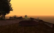
Verdant Bluffs as viewed from the southwest.
Verdant Bluffs is district in Los Santos, San Andreas. It is located south of Downtown Los Santos and immediately north of Los Santos International Airport. Also adjacent to the area are the districts of Verona Beach, El Corona, Commerce and the Los Santos Conference Center.
The main feature of the area is Verdant Bluffs itself, a large outcropping of rock. With over 2,000 acres of natural terrain, it is the largest municipal park and urban wilderness area in all of San Andreas.[1] There are no gang activities or safehouses here, although nearby districts Verona Beach and El Corona have prominent gang activities and a safehouse. The building at the top of the hill is the historic Los Santos Observatory based on the Griffith Observatory, but oddly the location and name has more in common with Palos Verdes. The Santa Maria Freeway Extension runs through a tunnel underneath the western hillside of the bluff for a short distance.
Businesses
Weapons and Pickups
Collectibles
See also
- The Galileo Observatory, the equivalent of the Griffith Observatory in Grand Theft Auto V
Gallery
Reference
- ↑ Grand Theft Auto: San Andreas - City Guides (PC manual) p.25
Template:Los Santos neighborhoods


